Log in
All resources
Create a design
2,713 Free Artworks of Travel Maps
french-language maps of spain
guide joanne espagne et portugal-1915
1915 maps
description and travel
smithsonian libraries
natural history
early works to 1800
french
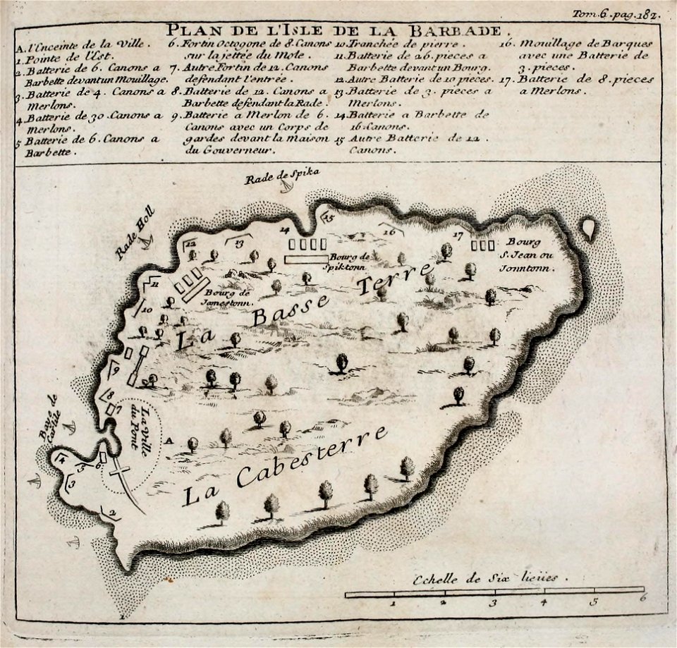
west indies
pre-linnean works
guide joanne espagne et portugal-1906
french-language maps of spain
guide joanne espagne et portugal-1915
1915 maps
guide joanne espagne et portugal-1915
1915 maps
guide joanne espagne et portugal-1906
french-language maps of spain
guide joanne espagne et portugal-1906
french-language maps of spain
guide joanne espagne et portugal-1915
1915 maps
guide joanne espagne et portugal-1906
french-language maps
guide joanne espagne et portugal-1915
1915 maps
eran laor cartographic collection
william hughes (geographer)
guide joanne espagne et portugal-1906
french-language maps
guide joanne espagne et portugal-1915
1915 maps
guide joanne espagne et portugal-1915
1915 maps
voyage dans la russie méridionale et la crimée (1840-1842) par anatolii nikolaevich demidov
1853 maps of russia
17th-century maps of the eastern mediterranean
1690s maps of turkey
1800 maps of the atlantic ocean
1800s maps of the americas
guide joanne espagne et portugal-1915
1915 maps
guide joanne espagne et portugal-1906
french-language maps of spain
walter riemer (illustrator)
1935 maps of germany
romanticism
1557 maps
guide joanne espagne et portugal-1915
1915 maps
old maps of england
1860 maps
select views in india, drawn on the spot, in the years 1780, 1781, 1782, and 1783
british library asia, pacific and africa collections
maya angelou
travel maps
the hand-book for travellers in italy, from london to naples (1838)
old maps of tuscany
guide joanne espagne et portugal-1915
1915 maps
guide joanne espagne et portugal-1915
1915 maps
maps of novaya zemlya
1590s maps
old maps of haarlem
museum haarlem
my early travels and adventures in america and asia (1895)
everett d. graff collection of western americana
guide joanne espagne et portugal-1915
1915 maps
media from the national library of finland
classicism
gulliver's travels (grandville)
symbolism
guide joanne espagne et portugal-1915
1915 maps
a voyage to abyssinia, and travels into the interior of that country, executed under the orders of the british government in the years 1809 & 1810
john outhett
tourism advertising posters of germany
germany in the 1930s
a voyage to abyssinia, and travels into the interior of that country, executed under the orders of the british government in the years 1809 & 1810
john outhett
maps by guillaume sanson
maps by nicolas sanson
illustrations from découverte de la terre
19th-century maps of cities
1840s maps showing history
maps by thomas starling
incidents of travel in central america, chiapas, and yucatan (1858)
romanticism
illustration
maps
incidents of travel in central america, chiapas, and yucatan (book)
romanticism
a voyage to abyssinia, and travels into the interior of that country, executed under the orders of the british government in the years 1809 & 1810
john outhett
voyages and travels to india, ceylon, the red sea, abyssinia, and egypt, vol. 3
henry cooper (engraver)
english-language maps
1747 maps of asia
journals of travels in assam, burma, bootan, affghanistan and the neighbouring countries (1847)
khyber pass maps
maps from the earth and its inhabitants, vol. xi
africa in the 1890s
old maps of vermandois
maps of somme river
travels on the continent, sicily, and the lipari islands (1829)
19th-century maps of sicily
maps by thomas starling
1842 maps
maps of abyssinia by mercator-hondius
old maps of guatemala
romanticism
navigantium atque itinerantium bibliotheca
1764 fleurons
maps of the ural mountains
russia (1913)
haarlem nautz map 1822-1829
old maps of haarlem
maps of saint paul's journeys
maps by thomas starling
dr. wilh. junker's reisen in afrika 1875-1886
1889 maps of africa
maps from the earth and its inhabitants, vol. ix
maps indicating exploration
voyages and travels to india, ceylon, the red sea, abyssinia, and egypt, vol. 2
henry cooper (engraver)
a.de la motraye's travels through europe, asia, and into part of africa (1723) by la mottraye
realism
travel
maps
maps of haarlemmerhout
old maps of haarlem
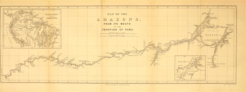
brazil
maps
voyages and travels to india, ceylon, the red sea, abyssinia, and egypt, vol. 2
henry cooper (engraver)
everett d. graff collection of western americana
st. louis, missouri in the 1800s
travels in the interior of north america, during the years 1832–1834
works by maximilian zu wied-neuwied
maps of abyssinia by mercator-hondius
voyages and travels to india, ceylon, the red sea, abyssinia, and egypt, vol. 3
henry cooper (engraver)
travels amongst the great andes of the equator (1894)
maps of the andes
sanson maps of the holy land
old maps of canaan
maps
wall
the land of the monuments (1896)
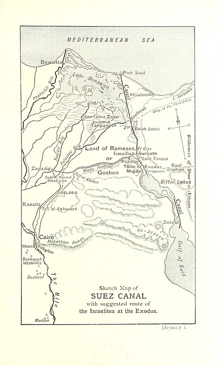
old maps of the suez canal
a voyage to abyssinia, and travels into the interior of that country, executed under the orders of the british government in the years 1809 & 1810
john outhett
voyages and travels to india, ceylon, the red sea, abyssinia, and egypt, vol. 3
henry cooper (engraver)
french
maps
french
maps
french
maps
voyages and travels to india, ceylon, the red sea, abyssinia, and egypt
blank back covers of books
french
maps
french
maps
voyages and travels to india, ceylon, the red sea, abyssinia, and egypt, vol. 3
henry cooper (engraver)
french
maps
old maps of south africa
emil holub
voyages and travels to india, ceylon, the red sea, abyssinia, and egypt, vol. 3
henry cooper (engraver)
travels amongst the great andes of the equator (1894)
maps of chimborazo volcano
1890s maps of south africa
emil holub
french
maps
illustration
maps
madagascar
maps
illustration
maps
atlas van der hagen (volume 4)
atlas van der hagen
americae 1562 by diego gutiérrez and hieronymus cock
renaissance
1770s maps of alaska
robert de vaugondy
islands
maps
maps of yosemite national park
volcano school
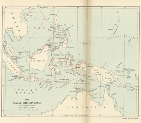
19th-century maps of the malay archipelago
the cruise of the marchesa (1889)
maps by thomas nast
1872 maps of texas
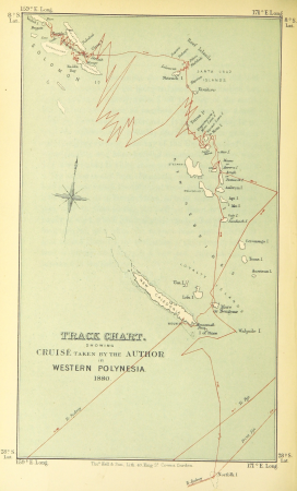
wanderings, south and east (1882)
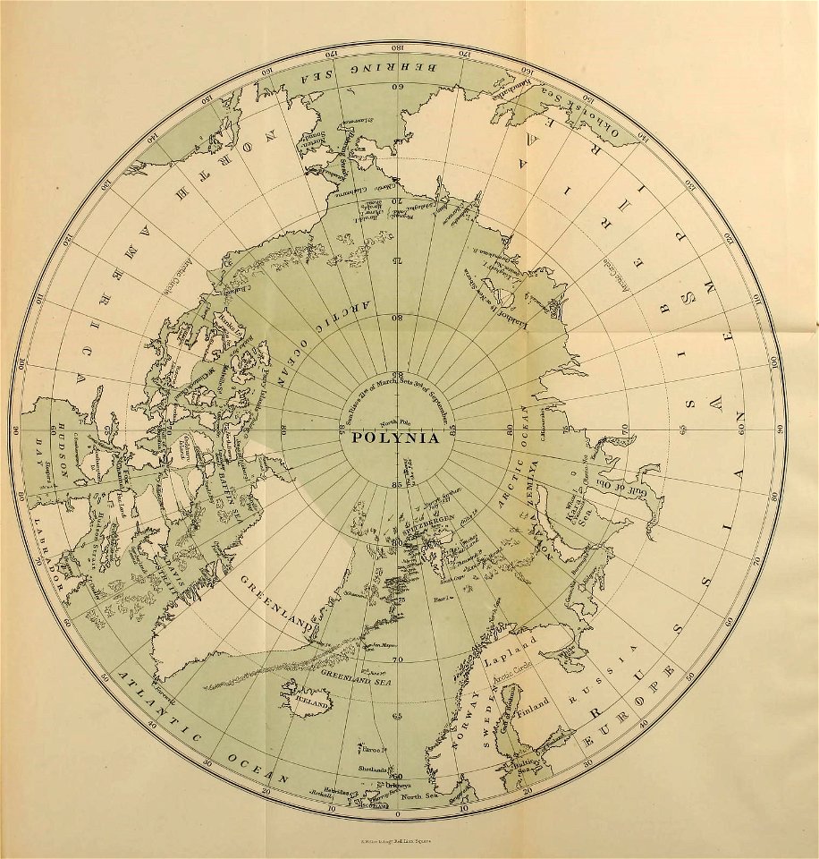
old maps of polynesia
a voyage to abyssinia, and travels into the interior of that country, executed under the orders of the british government in the years 1809 & 1810
john outhett
maps from the earth and its inhabitants, vol. ix
maps indicating exploration
101 - 200 of 2,713
Next page
/ 28


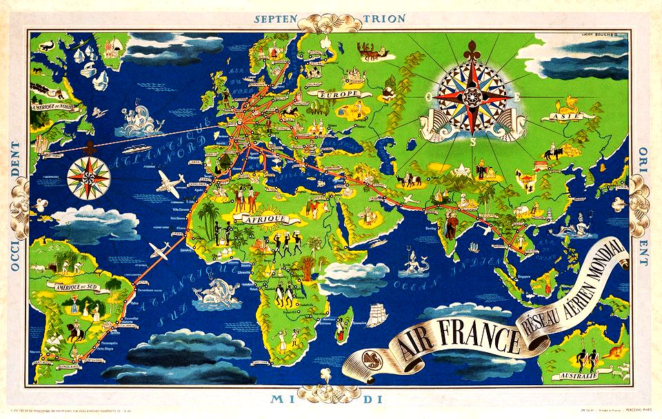
![BOUCHER, Lucien. Air France [zodiac map], 1953.](https://cdn.creazilla.com/illustrations/3148546/boucher-lucien-air-france-zodiac-map-1953-illustration-md.jpeg)


![The Course of the Somme in the vicinity of which course are situated, the Ponthieu, the Amienois, the Santerre and the Vermandois / By N. de Fer... Scale of Three Hours of Travel [=1: 139 200 ]; H. Van Loon sculp, Herman van Loon, 1709](https://cdn.creazilla.com/illustrations/10000794475/the-course-of-the-somme-in-the-vicinity-of-which-course-are-situated-the-ponthieu-the-amienois-the-santerre-and-the-vermandois-by-n-de-fer-scale-of-three-hours-of-travel-1-139-200-h-van-loon-sculp-herman-van-loon-1709-md.jpg)